
Dear Valued Shareholder,
2026 has been a pivotal year for Sonoro Gold (“Sonoro”) and its flagship Cerro Caliche gold project in Mexico. We announced positive and robust results from an updated Preliminary Economic Assessment (“PEA”), expanded Cerro Caliche to a potential district wide scale project, and commenced a 50,000-meter drilling program. These continue to demonstrate the presence of higher-grade mineralization outside the current Mineral Resource Estimate (“MRE”).
However, before I expand on those material developments, I want to first confirm our unwavering commitment to advance to production as soon as possible and provide an update on permitting. The primary objective of Sonoro is to develop an initial mining operation to generate funds for future growth and expansion.
In May 2022, the Company submitted its Environmental Impact Assessment (“Manifestacion de Impacto Ambiental” or “MIA”) for an open-pit, heap leach operation.
The MIA is one of two permits required for the construction and operation of a mine in Mexico along with mineral and surface rights. Sonoro has secured all mineral concessions and land rights for the proposed Cerro Caliche gold operation. The justification study, required for the second permit, the Change of Land Use (“Autorizacion en Cambio de Uso de Suelo” or “CUS”) has been completed and is ready for submission.
The MIA has undergone several revisions over the past few years to align with increasingly tighter technical and environmental requirements. In 2026, we completed extensive geotechnical and advanced engineering work, together with multi-seasonal baseline studies to demonstrate compliance with these standards. In parallel, we initiated a feasibility level design of the proposed heap leach facility that further derisks the project and supports its advancement towards development.
Updated PEA
In April 2026, Sonoro filed an updated PEA for a proposed 10-year life of mine, open pit, heap leach mining operation with a projected capacity of up to 16,000 tonnes per day. Based on approximately 30% of the known mineralized zones identified on the original property and utilizing a gold price of USD $3,500 per ounce, the PEA highlights an after tax NPV8 of USD $224M and an IRR of 50%. The report utilized an updated MRE based on a total of 46,765 metres of drilled data, including 419 drill holes.
District Land Consolidation
In 2026, Sonoro significantly expanded its Cerro Caliche project from 1,350 hectares to 8,215 hectares, while also securing a 51% interest in an additional 454 hectares. Through a series of acquisitions, Sonoro acquired 100% ownership of 34 mineral concessions located adjacent to the northern, eastern and southern boundaries of the project. In January 2026, 10 mineral concessions were acquired for total consideration of USD $4M and in April 2026, the Diana concession was acquired for a one-time payment of USD $600,000. Finally, between May and August 2026, 23 mineral concessions were acquired for total consideration of USD $5.17M.
Sonoro can also earn up to a 51% interest in five additional mineral concessions for a total commitment of up to USD $9M in exploration expenditures over four years, earning a 12.75% interest for each USD $2.25M of exploration expenditures incurred.
The Vendors of the concessions are at arm’s length to Sonoro, its associates and affiliates and the purchase considerations do not include the issuance of any securities, nor any grant of a royalty interest.
This expansion represents a strategic opportunity for Sonoro to build Cerro Caliche into a larger-scale gold mining project with multiple major mineralized zones stretching from the Santa Gertrudis mine in the north down to the Mercedes mine in the southeast. Together, the Santa Gertrudis and Mercedes mines have produced over 1.5M ounces of gold and an extensive review of geological data from the acquired concessions suggest the Cerro Caliche project is part of a much larger gold epithermal system.
Exploration
Cerro Caliche is a low-sulphidation epithermal system with more than 25 northwest-trending gold zones at or near surface. The same structural pattern of veins, breccias and rhyolitic dikes appear across the entire district. Historical data suggests the mineralized structural corridors at Cerro Caliche extend northward onto the recently acquired concessions.
In May 2026, drilling resumed at Cerro Caliche with a two-phase exploration campaign including an ongoing 50,000 meters of reverse circulation drilling, as well as soil and rock sampling programs. The objective of the program is to identify and expand known mineralized zones as well as to investigate structural continuity of the project’s northwest-trending mineralized corridors. Supported by over 30 years of exploration data from the recently acquired mineral concessions, the new expanded Cerro Caliche project has potential to host multiple mineralized zones.
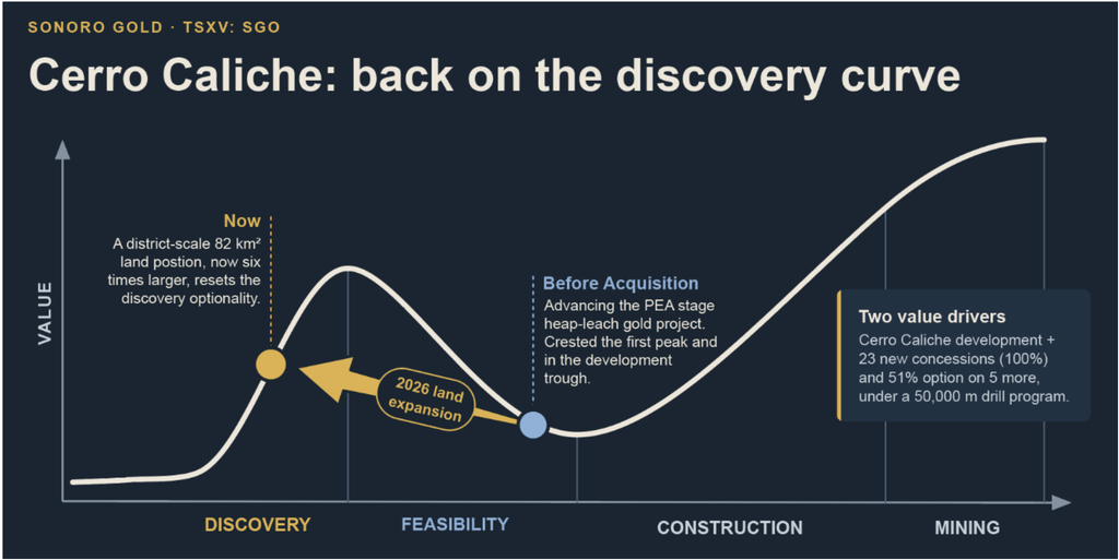
To date, we have announced the results from 95 reverse circulation (“RC”) drill holes with 58 completed within the central-western region of the property, where Sonoro proposes to develop its initial operation. An additional 37 drill holes have been completed in the northern regions in the newly acquired Diana and El Batamote concessions.
Central-Western Drilling Results
Drilling initially focused on the central-western region of the property where results confirmed geological continuity of gold mineralization within and surrounding the defined mineral resource, potentially connecting the proposed pit shells within the mine plan. Several drill holes returned higher grade intercepts, such as SCR-340 which intercepted 18.29m @ 3.39 g/t Au, including 9.14m @ 6.43 g/t Au and 10.67m @ 1.23 g/t Au, including 1.52m @ 7.12 g/t Au. Drill hole SCR-358 which intercepted 7.62m @ 0.63 g/t Au including 1.52m @ 2.11 g/t Au.
Targeted drilling also identified new mineralized zones near to the proposed open pit. Two drill holes at El Quince intersected higher grades of gold with high silver content, implying the zone was possibly downfaulted from a higher elevation. Drill hole SCR-348 intercepted 9.14m @ 3.076 g/t Au and 26.10 g/t Ag, including 6.09m @ 4.531 g/t Au and 37.5 g/t Ag. Drill hole SCR-349 intercepted 18.29m @ 1.674 g/t Au and 30.40 g/t Ag, including 6.10m @ 4.568 g/t Au and 84.60g/t Ag. Click here to view drilling results announced on September 1, 2026.
Diana Drilling Results
The new Diana concession lies outside the current MRE, approximately two kilometers northeast of the proposed pit shells. In 2018, we acquired geological data from prior operators at Diana including drill logs, assay certificates and rock and soil samples. Since this time, our exploration team have completed extensive mapping of the concession’s veins, faults, hydrothermal breccias and rhyolitic dikes and confirmed similarities to the known gold mineralization at Cerro Caliche.
The initial 14 drill holes completed at Diana confirmed the gold mineralization extend southeast across the Bellotoso Plateau towards the boundary of the project’s original property, as well as northwest towards the historic workings of El Batamote mine. Multiple higher-grade intercepts confirmed the presence of shallow, higher-grade gold mineralization supporting the potential for Diana to be another significant mineralized zone. Drill hole SCR-387 intercepted 28.95m @ 2.598 g/t Au, including 13.72m @ 5.101 g/t Au. Drill hole SCR-391 intercepted 32.0m @ 1.846 g/t Au, including 4.57m @ 10.430 g/t Au. Click here to view drilling results announced October 1, 2026.
An additional 21 drill holes over 4,691 meters has extended Diana mineralization by approximately 235 meters to the southeast, and intersected gold-silver mineralization to the northwest at the historic El Batamote mine. All 21 holes returned intervals grading at or above the reporting cut-off, with near surface mineralization starting within the first 30m downhole in 20 of the 21 drill holes. Drill hole SCR-399 intercepted 9.15m @ 1.286 g/t Au, including 4.57m @ 2.366 g/t Au. Drill hole SCR-404 intercepted 50.30m @ 0.823 g/t Au, including 1.52m @ 9.372 g/t Au.
El Batamote Drilling Results
We completed five drill holes at the historic El Batamote mine site, located approximately 1.2 km west-northwest of Diana. Each drill hole intersected gold-silver mineralization and may represent a continuation of the Diana mineralized corridors within a block downthrown by post-mineral faulting. Highlights include drill hole SCR-406 which intercepted 19.81m @ 1.13 g/t Au and 15.1 g/t Ag, including 1.52m @ 3.60 g/t Au and 58.5 g/t Ag, and 4.57m @ 2.35 g/t Au and 12.7 g/t Ag. Drill hole SCR-409 intercepted 15.24m @ 0.71 g/t Au and 10.1 g/t Ag, including 3.04m @ 1.77 g/t Au and 28.4 g/t Ag. Click here to view drilling results announced November 9, 2026.
The map below illustrates the proposed mine footprint, including the open pits, the original 1,350-hectare property boundary, the Diana concession, interpreted mineralized corridors, and mapped and projected faults. Drill hole locations are differentiated by category.
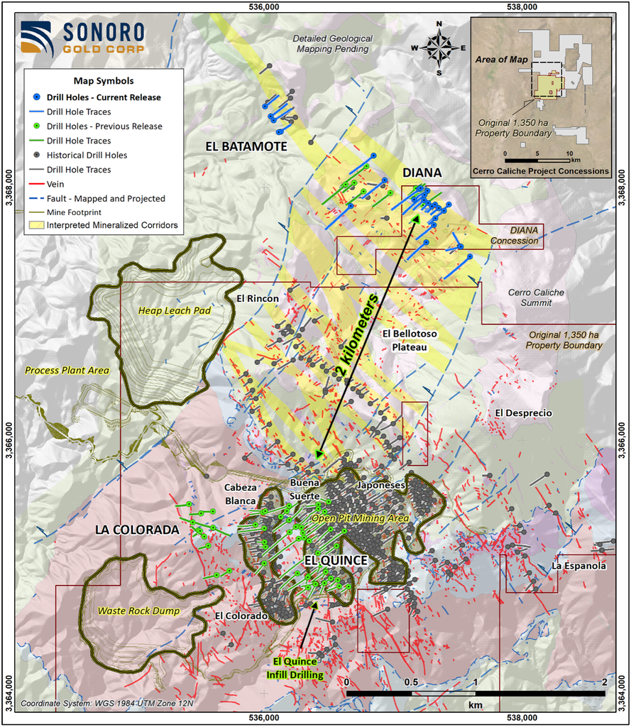
We have long believed Diana to be a significant extension of the northwest trending mineralized corridors located north of the Rincón–Bellotoso mineralized zone and the gold-silver mineralization identified at El Batamote is often seen in the upper levels of epithermal systems above high-grade feeder veins. However, additional structural, geochemical and drilling work is needed to confirm where El Batamote sits within the system.
Next Steps
Drilling results from Diana and El Batamote demonstrate that Cerro Caliche’s mineralized structural corridors extend northward onto the recently acquired concessions and we believe this exploration model can be applied across the full 8,215-hectare land position.
RC drilling continues west and northwest of Diana toward El Batamote and southwest across the Bellotoso Plateau toward the proposed open-pit mining operation. At El Batamote northern concessions, we are developing targets to test for possible extensions of the vein systems, including potential higher-grade gold zones within the interpreted downthrown block.
A planned drone-borne magnetic survey, together with the compilation and integration of historical data across the acquisitions, is expected to guide target selection and prioritization for Phase II drilling planned through spring 2027.
Results from Diana and El Batamote, as well as from the newly identified mineralized zones, will inform geological modelling and be evaluated for potential inclusion in a future NI 43-101 Mineral Resource Estimate update.
Strategic Investment by Palisades Goldcorp
In June 2026, Palisades Goldcorp Ltd. (“Palisades”) acquired 22 million units in Sonoro’s oversubscribed C$15.5 million private placement, increasing its holding to 37.25 million common shares, or approximately 8.69% of Sonoro’s issued and outstanding shares following the placement. Palisades began building its current position in Sonoro in 2025, when it led a C$5 million private placement, and its increased position this year reflects its continued confidence in Sonoro.
Palisades has expressed a direct interest in advancing the district-scale potential at and around Cerro Caliche. The investment forms part of Palisades’ longer-term strategy of backing opportunities that scale with Tier 1 potential in stable and emerging mining jurisdictions. Beyond its investment, the Palisades team is taking a hands-on role, contributing its extensive capital markets experience and geological expertise in gold systems of this kind. We welcome Palisades as a strategic investor as we advance Cerro Caliche through permitting and test the wider district.
Palisades has described its approach as backing undervalued assets in jurisdictions with low to moderate political risk, with a focus on long-term value as market conditions improve. We share that long-term perspective and we are pleased to have a shareholder of Palisades’ experience aligned with our plans for the district.
I look forward to updating shareholders as Phase I is completed and Phase II drilling continues at the newly acquired concessions.
As always, please contact me directly at john@sonorogold.com with any questions or comments on Sonoro or our mineral projects.
I also encourage you to join our online communities on X, Facebook, LinkedIn, Instagram and YouTube, and visit Sonoro’s website to view and/or sign-up for the latest news and presentations.
Kindest Regards,
John M. Darch, Chairman
Sonoro Gold Corp.
Cautionary Statements:
Drill results: The intercepts quoted are drilled interval lengths, uncut, from Bureau Veritas assay certificates, as reported in Sonoro’s news releases dated October 1, 2026 and November 9, 2026. True widths are estimated at approximately 60% to 90% of drilled lengths. These are exploration results only. They are not a mineral resource estimate and do not demonstrate economic viability.
Historical data: Historical exploration data on the newly acquired and optioned concessions was generated by previous operators. A Qualified Person has not verified this data, and it should not be relied upon. The PEA is preliminary in nature and includes Inferred Mineral Resources that are considered too speculative geologically to have economic considerations applied to them that would enable them to be categorized as mineral reserves, and there is no certainty the PEA will be realized. Mineral resources that are not mineral reserves do not have demonstrated economic viability.
Nearby properties: Information about the Santa Gertrudis and Mercedes mines and other nearby properties is not necessarily indicative of mineralization on Sonoro’s concessions.
Forward-looking statements: This letter contains “forward-looking information” as defined in applicable Canadian securities legislation, including statements regarding exploration plans and drill programs at Diana, El Batamote and across the Cerro Caliche district, the potential of the newly acquired and optioned concessions, the continuation of mineralized corridors onto the new ground, ongoing land consolidation, a future mineral resource update, permitting, and the proposed development of the Cerro Caliche project. Forward-looking statements are generally, but not always, identified by words such as “expects”, “plans”, “anticipates”, “believes”, “intends”, “estimates”, “potential”, “objective” and similar expressions, or statements that events or conditions “will”, “would”, “may”, “could” or “should” occur. They are based on the beliefs, estimates and opinions of management on the date of this letter and involve risks and uncertainties, including unfavourable exploration results, the lack of sufficient future financing to carry out exploration and development plans, and unanticipated changes in legal, regulatory and permitting requirements. Actual results and future events could differ materially from those anticipated. Readers should not place undue reliance on forward-looking statements. Sonoro disclaims any intention or obligation to update or revise any forward-looking statements, except as required by law or the policies of the TSX Venture Exchange. Readers are encouraged to review Sonoro’s complete public disclosure record on SEDAR+ at www.sedarplus.ca.
Neither the TSX Venture Exchange nor its Regulation Services Provider (as that term is defined in the policies of the TSX Venture Exchange) accepts responsibility for the adequacy or accuracy of this letter.
