 SONORO REPORTS GOLD MINERALIZED TARGETS IN NORTHWEST REGION OF CERRO CALICHE AS POTENTIAL RESOURCE EXPANSION
VANCOUVER, Canada, July 10, 2023 – Sonoro Gold Corp. (TSXV: SGO | OTCQB: SMOFF | FRA: 23SP) (“Sonoro” or the “Company”) is pleased to report oxide mineralized targets identified for resource expansion at the Company’s Cerro Caliche gold project, located in Sonora State, Mexico. Surface sampling and detailed geologic mapping completed in the northwest region of the property demonstrate three linear structural corridor repetitions with anomalous gold, silver and base metal mineralization, as well as a fourth visually inferred corridor.
Exploration to date at Cerro Caliche has identified a wide area of mineralized low-sulfidation epithermal vein structures and the presence of multiple northwest trending gold mineralized zones along trend and at near surface. A Mineral Resource Estimate report filed in March 2023 confirmed a section of the concession’s oxidized, shallow, gold mineralized resource that the Company is currently working on to bring into production with a proposed heap leach mining operation.
With just over 30% of the known mineralized gold zones at Cerro Caliche explored, the Company has identified the Northwestern Corridors Area as a priority drilling target for future drilling to expand the resource. The structural and veined corridors are located adjacent and parallel to the known El Rincón and Veta de Oro vein zones where previously announced drilling results confirm gold-silver mineralized intervals.
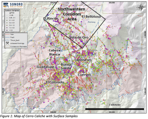
Assay results with data resolution from surface sampling, together with geologic mapping and adjacent drill holes, suggest the potential expansion of the project’s oxide gold mineralized zones and resource. Figure 1 below shows the locations of the surface samples and Northwestern Corridors Area.
Kenneth MacLeod, President and CEO of Sonoro, commented, “Targeting the oxide gold mineralization inside the Northwestern Corridors Area is intended to potentially expand the project’s resource. This expansion, along with the planned infill drilling targets at the higher-grade bodies of gold mineralization at El Colorado and Guadalupe vein zones, may enhance the overall economics of the Cerro Caliche project.”
Potential expansion of the Cerro Caliche’s resource will be discussed at an upcoming live webinar scheduled for Thursday, July 13, 2023 at 8am PST (11am EST). Click here for more information.
Surface sampling methods consisted of continuous chip sampling perpendicular across measured veins and wall rocks. Within the Northwestern Corridors Area, the Company has completed 608 samples with sample lengths of 1.0 to 2.0 meters and assays grades of up to 24.8 grams of gold per tonne (“g/t Au”). Within the same area, the Company completed 27 previously announced drill holes as part of its Phase 3 exploration program concluded in April 2021.
The host rock is the Tertiary age rhyolite sill with strong silicification and minor argillic alteration. A common characteristic of low-sulfidation epithermal mineralization in structures is increased gold at higher elevation levels within the boiling zones and increased silver at lower elevation levels within the boiling zones. Drilling will target the oxide gold mineralized northwestern corridors where favorable boiling textures and rock type for mineralization suggest possible higher gold grades and possibly greater vertical extent.
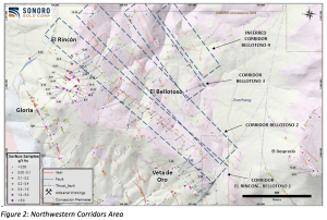
Figure 2 below illustrates the four corridors within the Northwestern Corridors Area and identifies samples with gold mineralization greater than 3.0 g/t Au. Silver values for the area are not shown but average silver mineralization is 16 grams of silver per tonne (“g/t Au”).
Northwestern Corridors Descriptions
- The Corridor El Rincón-Bellotoso 1 is approximately 1,500-meters long with the southeast end near the steep sloped Reina de Plata vein area to the offsetting post mineral northeast trending fault.
- The Corridor Bellotoso 2 is approximately 1,400-meters long with a southeast end where outcrops are sparse with mostly thick colluvium covered rock and the projected post mineral fault offsetting the mineralized structure.
- The Corridor Bellotoso 3 is approximately 750-meters long in the outcropping area with a possible 600-meter southeast extension beneath colluvium of soil, talus and alluvium.
- The Inferred Corridor Bellotoso 4 is projected with approximately 500-meters in length and a possible additional southeast extension beneath colluvium that ends at the northeast trending post-mineral fault.
Mel Herdrick, Sonoro’s VP of Exploration, noted that “Target drilling within the Northwestern Corridors Area will increase the degree of completed exploration of Cerro Caliche’s known mineralized gold zones from just over 30% to approximately 50%, and also potentially increase the project’s oxide gold resource.”
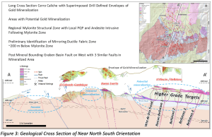
The geological cross-section below in Figure 3 identifies the four gold, vein-bearing target zones in the Northwestern Corridors with projected higher grade oxide gold mineralization. The cross-section also illustrates the importance of the newly defined Laramide age thrust fault’s Mylonite unit and associated shatter zone of permeable host rocks. This very fractured rock hosts much of the project’s defined gold mineralization that, as veins and veinlets were deposited with gold and silver into shattered rocks, formed wide areas of stockwork mineralization. Potential higher-grade mineralization may also have formed within these vein zones as they intersected the shattered zone around the mylonite and continued upward several hundred meters into overlying allochthonous rocks as in the adjacent Veta de Oro zone.
The cross-section is oriented slightly NE-SW crossing mineralized areas of El Colorado – Guadalupe and Buena Suerte before crossing into the higher elevation Rincon Plateau. Areas of potential higher grade mineralization are shown in the circled parts of veins above the mylonite. Projection of grade envelope plots of gold mineralization from drilling are indicated above the cross section. There is coincidence of gold mineralization grade shells with the position of the mylonite shatter zone which, along with gold mineralization, is projected to continue beneath the Rincon Plateau’s Northwest Corridors Area and beneath Cerro Caliche peak.
Oxide gold mineralized targets within the Northwestern Corridors Area are of shallow gold mineralization in near surface environments. However, the Company plans to also investigate the potential for broad mineralized zones at depth as previously announced drilling results from the Veta de Oro area intercepted higher-grade gold at an elevation equal to the zone at depth beneath the Rincon Plateau and Northwest Corridor Areas.
Quality Assurance/Quality Control (“QA/QC”) Measures and Analytical Procedures
Samples are collected as continuous chip samples by hand and placed into plastic bags, GPS positions and rock descriptions noted, the bags are numbered using ALS-Chemex bar code number books, then sealed and taken to secure storage in Cucurpe village near the project.
Company personnel transport those bagged samples directly to the preparation laboratory of ALS- Chemex in Hermosillo, Sonora. At the preparation laboratory, samples are logged into ALS-Chemex system using bar code labels, opened, then reduced in size through crushing, splitting and pulverization. About 200 grams of each sample are sent by ALS-Chemex to their Vancouver, Canada laboratory where samples are individually dissolved in aqua regia for multi-element ICP analysis, including silver. Thirty grams of each pulverized sample is split apart in that laboratory and undergoes a “Fire Assay” for gold content by reducing the fire assay to a concentrated button of material that is dissolved in acids. From the solution, the gold content is determined by atomic absorption. Quality control standards were inserted by the ALS-Chemex, Vancouver, B.C. laboratory.
No QA/QC issues were noted with the results received from the laboratory.
Geologic Description
Cerro Caliche is located 45 kilometers east southeast of Magdalena de Kino in the Cucurpe-Sonora Mega-district of Sonora, Mexico. Multiple historic underground mines were developed in the concession, including Cabeza Blanca, Los Cuervos, Japoneses, Las Abejas, Boluditos, El Colorado, Veta de Oro and Espanola. Mineralization types of the Cucurpe-Sonora Mega-district include variants of epithermal low sulfidation veins and related mineralized dikes and associated volcanic domes. Local altered and mineralized felsic dikes cut the mineralized meta-sedimentary rock units and may be associated with mineralization both in the dikes and meta-sedimentary rocks.
Qualified Person Statement
Stephen Kenwood, P.Geo., a Director of Sonoro, is a Qualified Person within the context of National Instrument 43-101 (NI 43-101) and has read and approved this news release. Readers are cautioned that the presence of mineralization on historic mines adjacent to or on Cerro Caliche is not necessarily indicative of economic gold mineralization in the concessions held by the Company.
About Sonoro Gold Corp.
Sonoro Gold Corp. is a publicly listed exploration and development company holding the near development stage Cerro Caliche project and the exploration stage San Marcial project in Sonora State, Mexico. The Company has highly experienced operational and management teams with proven track records for the discovery, funding and development of natural resource deposits.
On behalf of the Board of SONORO GOLD CORP.
Per:
“Kenneth MacLeod”
Kenneth MacLeod
President & CEO
For further information, please contact:
Sonoro Gold Corp. – Tel: (604) 632-1764
Email: info@sonorogold.com
Forward-Looking Statement Cautions:
This press release may contain “forward-looking information” as defined in applicable Canadian securities legislation. All statements other than statements of historical fact, included in this release, including, without limitation, statements regarding the future exploration and development on the Cerro Caliche project, and future plans and objectives of the Company, constitute forward looking information that involve various risks and uncertainties. Forward-looking information is based on a number of factors and assumptions which have been used to develop such information, but which may prove to be incorrect, including, but not limited to, assumptions in connection with the continuance of the Company and its subsidiaries as a going concern, general economic and market conditions, mineral prices and the accuracy of Mineral Resource Estimates. There can be no assurance that such information will prove to be accurate and actual results and future events could differ materially from those anticipated in such forward-looking information. Important factors that could cause actual results to differ materially from the Company’s expectations include exploration and development risks associated with the Company’s projects, the failure to establish estimated Mineral Resources, volatility of commodity prices, variations of recovery rates, and global economic conditions. The forward-looking information contained in this release is made as of the date of this release. The Company disclaims any intention or obligation to update or revise any forward-looking statements, whether as a result of new information, future events or otherwise, except as required by law or the policies of the TSX Venture Exchange. Readers are encouraged to review the Company’s complete public disclosure record on SEDAR at www.sedar.com.
Neither the TSX Venture Exchange nor its Regulation Services Provider (as that term is defined in the policies of the TSX Venture Exchange) accept responsibility for the adequacy or accuracy of this release.


