
SONORO GOLD REPORTS MULTIPLE HIGH GRADE GOLD INTERCEPTS AT CERRO CALICHE
INCLUDING 27.43 METERS OF 5.36 GRAMS OF GOLD PER TONNE
![]()
VANCOUVER, Canada, March 1, 2022 – Sonoro Gold Corp. (TSXV: SGO | OTCQB: SMOFF | FRA: 23SP) (“Sonoro” or the “Company”) is pleased to report the initial assay results from the first 24 drill holes of a 10,000-meter drilling campaign currently underway at its Cerro Caliche gold project in Sonora, Mexico. The objective of the program is to increase the estimated size and grade of the project’s oxide gold mineralization as well as to establish a basis for an extension of the estimated life of the proposed heap leach mining operation as outlined in the Preliminary Economic Assessment and updated Mineral Resource Estimate filed under the Company’s profile on SEDAR on October 29, 2021 (the “Mineral Resource Estimate”).
The results include drilling conducted in the gold mineralized zones of El Colorado and Guadalupe, located in the southwestern region of the property, where assays returned multiple higher-grade gold intercepts within larger intervals of high-grade gold mineralization. Drilling is continuing at both zones.
Highlights are as follows:
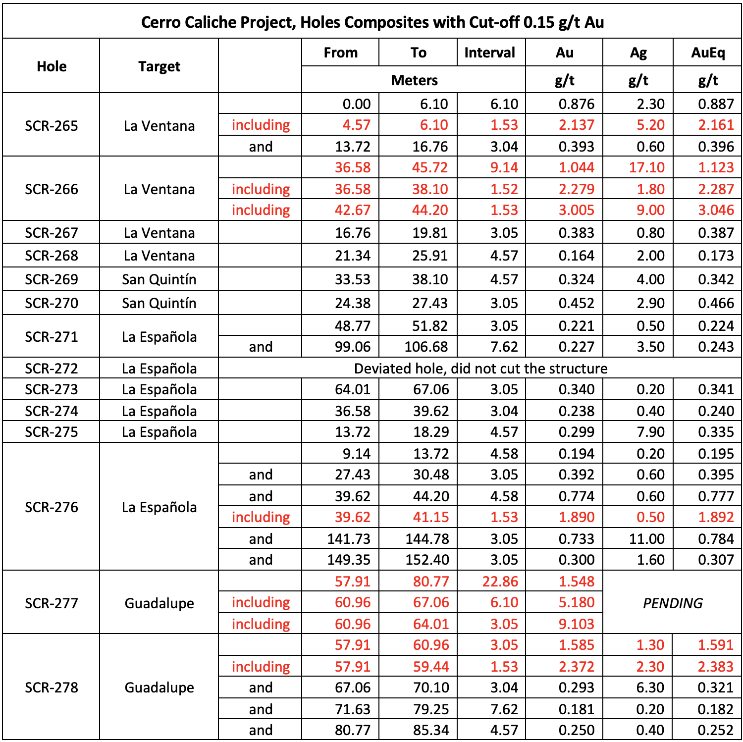
- SCR-266 intercepted 9.14m averaging 1.04 g/t Au; including 1.52m averaging 2.28 g/t Au; including 1.53m averaging 3.01 g/t Au
- SCR-277 intercepted 22.86m averaging 1.55 g/t Au; including 6.10m averaging 5.18 g/t Au; including 3.05m averaging 9.10 g/t Au
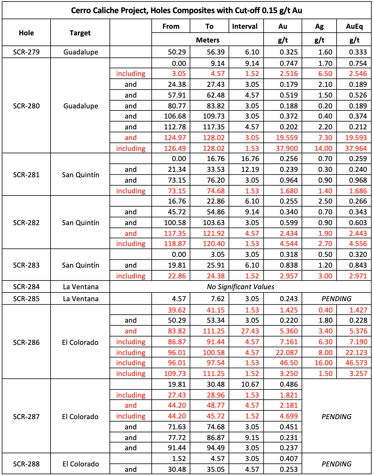
- SCR-280 intercepted 3.05m averaging 19.56 g/t Au; including 1.53m averaging 37.90 g/t Au
- SCR-282 intercepted 4.57m averaging 2.43 g/t Au; including 1.53m averaging 4.54 g/t Au
- SCR-286 intercepted 27.43m averaging 5.36 g/t Au; including 4.57m averaging 7.16 g/t Au; including 4.57m averaging 22.09 g/t Au; including 1.53m averaging 46.5 g/t Au
- SCR-287 intercepted 4.57m averaging 2.18 g/t Au; including 1.52m averaging 4.70 g/t Au
Mel Herdrick, Sonoro’s VP of Exploration commented, “These results indicate that we are successfully extending gold mineralization at Cerro Caliche while simultaneously demonstrating the potential for higher-grade mineralized zones deeper in the system.”
John Darch, Sonoro’s Chairman noted, “We are very pleased with these drilling results. The shallow high-grade drill intercepts and higher-grade gold intercepts at depth suggest the potential to increase both size and grade of the project’s resource, which, if confirmed, may not only extend the life of the proposed heap leach mine, but also may improve the overall economics of the project.”
Kenneth MacLeod, Sonoro’s CEO and President added, “These positive assay results support our decision to continue drilling while moving forward with the proposed development of an open pit mining operation. Confirmation of higher-grade intercepts at depth may suggest the possibility for underground gold mineralization. Further geological data is required, but we are very encouraged by these initial results.”
The map below illustrates the location of the drill holes.
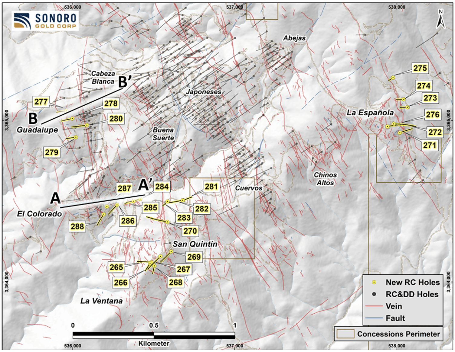
Figure 1: New Drill Holes
El Colorado Zone
When combined with prior drilling results, the current Infill and expansion drilling at the higher-grade El Colorado gold mineralized zone, reveal the presence of blind (lack of surface exposure) irregular higher-grade, low angle vein occurrences. These occurrences range from 10 to 70 meters below the present surface and may be included in future open pit cone determinations.
Drill hole SCR-286 intercepted high-grade gold mineralization at the deepest level of El Colorado’s epithermal system drilled to date. Near the bottom of the hole, a 27.43 meter intercept averaged 5.36 g/t Au, including 4.57 meters averaging 7.16 g/t Au, and 4.57 meters of 22.09 g/t Au, including 1.53 meters averaging 46.5 g/t Au and 1.52 meters averaging 3.25 g/t Au. As drilling stopped at this last gold intercept, future close-in drilling is planned to test for potentially deeper extension of the drill hole’s mineralization.
The high-grade SCR-286 intercept consists of vein and mega stock work located approximately 120 vertical meters lower than the resource pit cone used to calculate the zone’s gold resource in the updated Mineral Resource Estimate. The intercept begins underneath a gulley 80 meters immediately southeast of the pit cone proposed for the north slope of the gulley, and approximately 75 meters below surface with the mineralization continuing southeast under the south slope of the gully. Mineralization at El Colorado remains open to the northwest, the southeast and to depth.
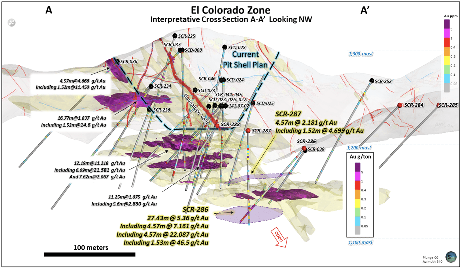
Figure 2: Interpretive Cross Section at El Colorado
Guadalupe Zone
At Guadalupe, SCR-277 intercepted 22.86 meters averaging 1.55 g/t Au, including 6.10 meters of 5.18 g/t Au and 3.05 meters of 9.10 g/t Au starting approximately 40 meters below surface. Located one kilometer north of SCR-286, the results suggest a continuation of the El Colorado vein system. At the deepest level to date within the Guadalupe epithermal system, SCR-280 intercepted 3.05 meters averaging 19.56 g/t Au, including 1.53 meters averaging 37.90 g/t Au.
The higher-grade zone’s repetitive character likely is due to a higher degree of shearing at the footwall of the Guadalupe vein structure. The footwall shows stronger shear character including mylonitic vein textures locally. As the zones have a horizontal character (with some low angle dips), a reverse faulting episode generated the necessary open space to permit near horizontal quartz veins to be deposited early in mineralization with later gold deposition. The possibility of these types of veins forming in other parts of the property is being reviewed but the entire structural zone around the Guadalupe vein structure may be permissive over more than 100 meters width.
The intercepts of higher-grade gold vein material at depth, may suggest the potential for underground gold mineralization in addition to the potential for the near-surface mineralization to be incorporated into the proposed Cabeza Blanca pit shell. Additional drilling is expected to add to the near-surface mineralization potential and drilling at depth will explore the underground potential.
Guadalupe was excluded from the updated Mineral Resource Estimate due to its lack of sufficient drilling density. The zone is located parallel to the west side of Cabeza Blanca. Some parts of the Guadalupe zone may be included with the Cabeza Blanca resource in future estimations.

Figure 3: Interpretive Cross Section of Guadalupe
El Colorado/La Ventana – Guadalupe/Cabeza Blanca Corridors
Four “scout holes” drilled to the southeast along the extension of the El Colorado/La Ventana – Guadalupe/Cabeza Blanca structural corridors confirmed mineralization continues by approximately 400 meters to the south, for a total length of 1.5 kilometers. Drill hole SCR-265 at La Ventana intercepted 6.10 meters averaging 0.88 g/t Au, including 1.53 meters averaging 2.14 g/t Au and drill hole SCR-266 intercepted 9.14 meters averaging 1.04 g/t Au, including 1.52 meters averaging 2.28 g/t Au and 1.53 meters averaging 3.01 g/t Au. Assay results on an additional four drill holes are pending but the visual identification of quartz vein material in chip logs suggests a good potential for gold.
Drilling with programed inclined RC drill holes is focused on extending gold mineralization south of the existing mineralized zones where near surface extension drilling is focused on adding to the existing resource areas. Access into the newly extended corridor had been limited until recently constructed roads enabled the Company to undertake an extensive sampling and mapping program, providing higher-grade targets for the current drilling program.
The geology in the newly drilled southern extension is similar to the geology of known mineralized zones to the north. Higher-grade sampled vein zones extend along similar trends from the north into the extended corridor area, with the drill holes stepping out about 400 meters south. Host rock is a complex of dioritic to granodiorite intrusive with later crosscutting andesitic dikes, similar to host rock in the El Colorado gold mineralized area.
Drill hole lengths are variable ranging from approximately 70 meters to 140 meters. Intervals intercepted indicate the vein structural zones continue south beyond previously drilled holes with higher gold values. The true dips are currently unknown but true widths are expected to be 80% or more of reported widths. Gold/silver ratios remain low with elevated lead content indicating deeper epithermal modeled levels.
La Española Zone
Another area excluded from the Mineral Resource Estimate was La Española, located in the southeast region of the property. Six scout drill holes completed at La Española suggest lower grade mineralization in the northward extension of the vein zone. SCR-276 intercepted 4.58 meters averaging 0.77 g/t Au including 1.53 meters averaging 1.89 g/t Au. This new data will be assessed in conjunction with the data from the prior drill holes to determine the potential for the zone.
Drilling continues to advance at Cerro Caliche with 30 drill holes completed to date. COVID related delays in the completion of laboratory analyses have created significant sample backlogs and delayed the announcements of drilling results. To expedite material information to shareholders, four of the drill holes listed below include only gold assays while silver assay results are pending. Full assay results from the four drill holes will be available on the Company’s website once received.
The following table provides the assay results for the complete list of reported drill holes:
Drill collar locations, azimuths and dips for the drill holes included are provided in the table below.
Quality Assurance/Quality Control (“QA/QC”) Measures and Analytical Procedures
Drill samples are collected with an airstream cyclone and passed into a splitter that divides each sample into quarters. The quartered samples are then bagged and sealed with identification. The sample group has blanks, standards and duplicates inserted into the sample stream.
Bureau Veritas (BV) collects from the drill site the samples and transports them directly to the preparation laboratory in Hermosillo, Sonora. At the prep. laboratory, a split part of each sample (about 500 grams) is reduced through crushing, splitting and pulverization. Thirty grams of each pulverized sample is split apart in the Hermosillo laboratory and undergoes a “Fire Assay” for gold content by reducing the fire assay to a concentrated button of material that is dissolved in acids and the gold content determined by atomic absorption. About another 200 grams of each sample are sent by BV to their Vancouver, Canada laboratory and dissolved there in aqua regia for multi-element ICP analysis, including silver.
ALS-Chemex collects the samples and transports them directly to the preparation laboratory in Hermosillo, Sonora. At the laboratory, part of each sample is reduced through crushing, splitting and pulverization from which 200 grams is sent to the ALS-Chemex assay laboratory in Vancouver. Thirty grams undergoes fire assay for gold with the resulting concentrated button of material produced is dissolved in acids and the gold is determined by atomic absorption. Another quantity of the sample is dissolved in four acids for an ICP multi-element analysis.
No QA/QC issues were noted with the results received from either laboratory.
Geologic Description
Cerro Caliche is located 45 kilometers east southeast of Magdalena de Kino in the Cucurpe-Sonora Mega-district of Sonora, Mexico. Multiple historic underground mines were developed in the concession including Cabeza Blanca, Los Cuervos, Japoneses, Las Abejas, Boluditos, El Colorado, Veta de Oro and Espanola. Mineralization types of the Cucurpe-Sonora Mega-district include variants of epithermal low sulfidation veins and related mineralized dikes and associated volcanic domes. Local altered and mineralized felsic dikes cut the mineralized meta-sedimentary rock units and may be associated with mineralization both in the dikes and meta-sedimentary rocks.
Qualified Person Statement
Stephen Kenwood, P.Geo., a Director of Sonoro, is a Qualified Person within the context of National Instrument 43-101 (NI 43-101) and has read and approved this news release. Readers are cautioned that the presence of mineralization on historic mines adjacent to or on Cerro Caliche is not necessarily indicative of economic gold mineralization in the concessions held by the Company.
About Sonoro Gold Corp.
Sonoro Gold Corp. is a publicly listed exploration and development company with a portfolio of exploration-stage precious metal properties in Sonora State, Mexico. The Company has highly experienced operational and management teams with proven track records for the discovery and development of natural resource deposits.
On behalf of the Board of SONORO GOLD CORP.
Per:
“Kenneth MacLeod”
Kenneth MacLeod
President & CEO
For further information, please contact:
Sonoro Gold Corp. – Tel: (604) 632-1764
Email: info@sonorogold.com
This press release may contain “forward-looking information” as defined in applicable Canadian securities legislation. All statements other than statements of historical fact, included in this release, including, without limitation, statements regarding the Cerro Caliche project, and future plans and objectives of the Company, constitute forward looking information that involve various risks and uncertainties. Although the Company believes that such statements are reasonable based on current circumstances, it can give no assurance that such expectations will prove to be correct. Forward-looking statements are statements that are not historical facts; they are generally, but not always, identified by the words “expects”, “plans”, “anticipates”, “believes”, “intends”, “estimates”, “projects”, “aims”, “potential”, “goal”, “objective”, “prospective” and similar expressions, or that events or conditions “will”, “would”, “may”, “can”, “could” or “should” occur, or are those statements, which, by their nature, refer to future events. The Company cautions that forward-looking statements are based on the beliefs, estimates and opinions of the Company’s management on the date the statements are made and they involve a number of risks and uncertainties, including the possibility of unfavorable exploration and test results, the lack of sufficient future financing to carry out exploration and development plans and unanticipated changes in the legal, regulatory and permitting requirements for the Company’s exploration programs. There can be no assurance that such statements will prove to be accurate, as actual results and future events could differ materially from those anticipated in such statements. Accordingly, readers should not place undue reliance on forward-looking statements. The Company disclaims any intention or obligation to update or revise any forward-looking statements, whether as a result of new information, future events or otherwise, except as required by law or the policies of the TSX Venture Exchange. Readers are encouraged to review the Company’s complete public disclosure record on SEDAR at www.sedar.com.
Neither the TSX Venture Exchange nor its Regulation Services Provider (as that term is defined in the policies of the TSX Venture Exchange) accept responsibility for the adequacy or accuracy of this release.